
A New Line of Defense for Dam Safety: Millimeter‑Level Inclination and Water Level AI‑Integrated Control
Release time:
2025-06-13
Hydropower dam Ectopic tilt Security Inspection Solution
One . Industry Status Quo
As critical national infrastructure, hydraulic dams have long faced safety risks such as dam‑body tilting, abnormal water levels, and seepage hazards. Conventional monitoring methods struggle to capture in real time the subtle changes in dam‑body inclination and the fine‑grained fluctuations of water levels.
Especially under extreme operating conditions such as heavy rainfall and flood discharge, manual inspections are both high-risk and inefficient. This solution achieves integration by… Three-axis high-precision inclinometer and Millimeter-wave radar level gauge ,
Combine AI Algorithms and multimodal transmission technologies enable millimeter‑level, real‑time monitoring of dam‑body tilt, water level, seepage flow, and other parameters, providing a round‑the‑clock, multidimensional intelligent protection system for hydraulic engineering projects.
Two . Safety Monitoring system
2.1 Overall System Functions
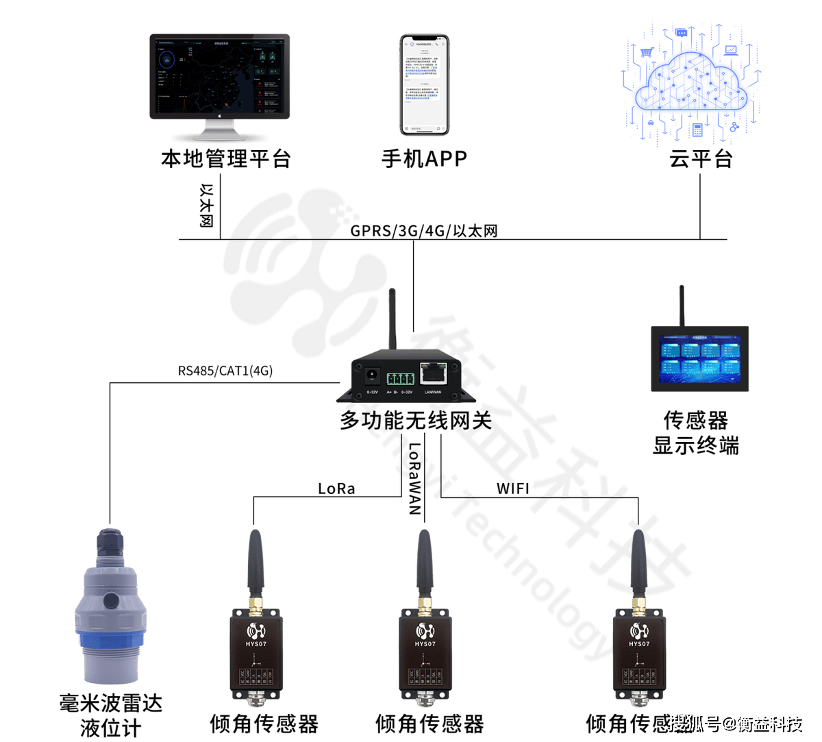
This system centers on an inclinometer and a millimeter-wave radar level gauge, integrating multi-source sensors, edge computing, and an intelligent cloud platform to accurately monitor the structural health of dams.
Inclinometer: Measures the horizontal alignment of the dam in real time. /Vertical inclination angle, with an accuracy of ±0.001°, capable of detecting minute changes such as dam foundation settlement and slope displacement.
Millimeter-wave radar level gauge: non-contact measurement of water levels in reservoir areas, measurement range 0–100 m, accuracy ±1 mm, resistant to rain and snow interference, suitable for complex meteorological conditions.
Intelligent Early-Warning Platform: Based on Tilt Angle - Water-level correlation model for predicting dam‑body instability risks and triggering tiered alarms.
The following This is the block diagram of the system:
2.2 Core Equipment Deployment
Inclinometer Deployment Plan
Monitoring locations:
The dam crest–dam foundation interface, the spillway gate support structure, and the slope anchorage zone.
Geological fault zones and areas of historical deformation.
Installation method:
Embedded base: Secured with a stainless steel bracket, seismic resistance rating Level 8 or higher.
Dual-axis /Three-axis configuration: Simultaneously monitors tilt along the X, Y, and Z axes and supports dynamic calibration.
Millimeter-Wave Radar Level Gauge Deployment Plan
Installation location:
The area near the dam, the upstream section of the spillway, and the outlet of the diversion tunnel.
Areas sensitive to abrupt water level changes (e.g., the gate opening/closing section).
Technical Advantages:
80 GHz high-frequency millimeter wave: boasts strong penetration through rain and fog, with measurement accuracy unaffected by surface water fluctuations.
Adaptive algorithm: automatically filters out floating-object interference and outputs stable water-level data.
Communication link:
LoRaWAN backhaul: Low-power wide-area coverage, supporting ultra-long-range transmission up to 10 km.
2.3 Wireless Transmission and Cloud Platform
Cloud platform

Data Transmission Technology
Inclinometer data: via LoRa/4G Dual-mode transmission with automatic offline caching ensures zero loss of high-priority tilt data.
Millimeter-wave radar data: fiber optic +5G Redundant links ensure the real-time performance and continuity of water-level data.
Core Functions of the Cloud Platform
Inclination angle - Water Level Correlation Analysis:
Dynamically compute the correlation coefficient between the dam’s slope angle and water level fluctuations to identify anomalous association patterns.
Example: When the water level rises rapidly, if the rate of increase in the dam crest’s slope angle exceeds the threshold, an automatic dam‑breach risk warning is triggered.
3D Visualization Dashboard:
Integrate inclinometer data to generate a thermal map of dam‑body inclination, and overlay it with a millimeter‑wave radar water‑level surface model.
AI Prediction Engine:
Train the dip angle based on historical data. - Displacement prediction model, in advance 7 Tian early warning of the dam body’s instability trend.
2.4 Inclination sensor
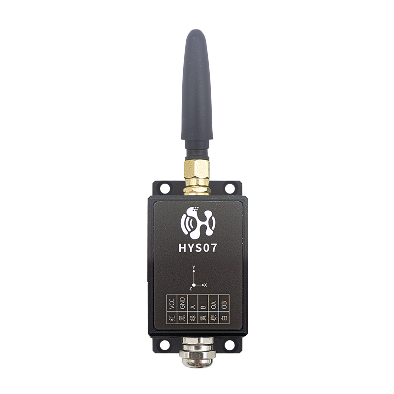
HYS07 The tilt sensor features high precision, low power consumption, and excellent stability, enabling real-time monitoring of an object’s tilt status and via… LoRa/LoRaWAN/Cat1/WIFI The device transmits data to the cloud platform in real time, enabling users to monitor and manage it remotely. Featuring a metal enclosure and a high-capacity battery, it also supports external power input and includes intelligent alarm functionality, with support for… TCP 、 UDP 、 MQTT and various other protocols, built-in SD The card supports automatic data retransmission upon network disconnection and is widely applicable across industries such as building construction, geological exploration, tower monitoring, smart cities, and industrial automation.
| Interface Name |
Specifications |
Explanation |
| Power supply |
DC 9~36V |
Wide-voltage power supply |
| RS485 |
1 road |
Standard MODBUS |
| LORA |
External antenna |
Support LORA/LORAWAN |
| Shell |
CNC |
IP67( Anti-splash ) |
| Installation |
Screw fastening |
|
| Inclination accuracy |
±0.01° |
|
| Inclination resolution |
0.005° |
|
| Tilt angle detection range |
|
|
| Digital output |
Digital output, load current 1A, Maximum voltage 60V |
Application in platform‑free scenarios, with an external audio‑visual alarm device. |
2.5 Alarm terminal
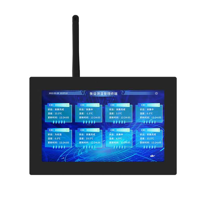
The alarm terminal is used for centralized management of multiple tilt sensors. It can simultaneously display the readings from several tilt sensors on the screen.
| Project |
Parameter |
Note |
|
| Display Function |
Display types |
TFT true color |
|
| Display resolution |
1024X600 |
|
|
| Types of touch controls |
High-precision capacitive touchscreen |
|
|
| Sensor display count |
Supports multiple display modes; you can display one in full screen, or 2, with a maximum of 16 displayed simultaneously. |
|
|
| Display size |
10.1 inches |
|
|
| System Functions |
Real-time data |
It can display sensor data in real time on the screen in multiple formats. |
|
| Historical data |
It can store historical data for more than one year and allows you to easily display this data on the touchscreen. |
|
|
| Control method |
You can directly manipulate the screen with your hands to zoom in and out. |
|
|
| Supported sensor types |
Supports temperature and humidity, temperature, Data from multiple sensors, including PM2.5/PM10, TVOC, formaldehyde, and CO2. |
|
|
| Data Upload |
10/100M Ethernet and 3G/4G/5G |
Not supported by default. 5G |
|
| Communication protocol |
Local support LORA, LORAWAN integration with sensors, Remote support MQTT connectivity to the cloud platform. |
|
|
| Local Wireless |
Support LORA wireless communication, with a frequency range of 31 MHz to 915 MHz. |
Wireless communication is an optional accessory; the default frequency band is 470MHZ |
|
| Product Specifications |
Operating temperature |
-30 °C ~65 °C |
|
| Operating humidity |
5%RH~90%RH |
|
|
| Certification |
CE/FCC |
|
|
| Power supply |
6V~12V |
|
|
2.6 mm millimeter-wave radar level gauge
Radar Level Gauge Product Series , refers to working in 76-81GHz Frequency-modulated continuous wave (FMCW) Radar products. The maximum range of the product can reach 15m, The blind spot is in 14 cm Within. Because it operates at a higher frequency , Greater bandwidth , Make it resistant to liquids,
of media such as slurries and solids Higher measurement accuracy. The product features a mounting bracket, eliminating the need for on-site wiring and making installation quick and easy. 。

| Project |
Parameter |
Note |
| Power supply |
12/24V DC |
Supports wide voltage range |
| Transmission frequency |
79 GHz~81GHz |
|
| Measurement range |
0.14 m ~ 15m |
0~140mm For radar blind spots |
| Measurement accuracy |
± 5 mm |
|
| Resolution |
1mm |
|
| FOV |
Level 25°x Vertical 15° |
Angle after adding the housing |
| Transmit power |
12dbm |
|
| Response time |
200ms |
|
| RS485 |
Support |
Default support |
| LORA |
Support |
|
| LoRaWAN |
Support |
|
| 4G |
Optional configuration |
CAT1 |
| Relay output |
1 Channel, optional |
|
| 4~20mA Output |
Optional configuration |
|
| Protection rating |
IP68 |
|
| Installation method |
Bracket / Thread |
|
- Solution Value :
Precision Prevention and Control: Inclinometer + Dual-core millimeter-wave radar monitoring enables closed-loop analysis of multiple parameters, including tilt, water level, and seepage.
Efficient operations and maintenance: reduce 85% of inspections are conducted manually, with remote diagnostics enabling rapid identification of potential hazards.
Compliance Enhancement: Meets the requirements of the “Code for Design of Safety Monitoring in Water Conservancy and Hydropower Projects” ( SL725-2016) Technical Requirements.
Cost Optimization: Maintenance-free design for millimeter-wave radar, reducing lifecycle costs. 50%.
IV. Applicable scenarios:
Joint Monitoring of Earthfill Dam Slope Angles and Water Levels
Earth-rockfill dams are prone to lateral sliding of the dam body due to sudden rises in water levels. This solution monitors the slope angle using inclinometers, employs millimeter-wave radar to track water levels in real time, and calculates safety thresholds on a central platform. For example, during the flood season, one particular earth-rockfill dam was observed to experience a water level rise of per hour. 0.5 m, with the inclination angle increasing by 0.02°,
The system automatically activates the flood‑discharge gates to mitigate landslide risks.

Deformation Analysis of Concrete Arch Dams
Arch dams are extremely sensitive to changes in dip angle. The proposed scheme deploys triaxial inclinometers at the abutments and the arch crown, coupled with millimeter-wave radar to monitor reservoir water levels. An AI model analyzes the relationship between dip angle and water pressure. At a certain arch dam, the system detected an abnormal dip angle at the left abutment; subsequent investigation revealed seepage through bedrock fractures, prompting timely grouting for reinforcement.

Water Slope Stability Monitoring in the Reservoir Area
The slope angle and the groundwater level jointly exert a significant influence on dam safety. The proposed solution employs an array of inclinometers. + Millimeter-wave radar monitors surface water levels, while GNSS stations track slope displacements. In one reservoir area, the slope’s dip angle exceeded 0.05° in a single day, coinciding with an abnormal drop in water level; this was classified as a potential landslide, prompting the emergency evacuation of downstream residents.

With Inclinometer and Millimeter-wave radar level gauge At its core, through a multi-source sensor network and An AI cloud platform enables millimeter‑level precision monitoring of dam inclination, water levels, and deformation. It supports dynamic correlation analysis between tilt angles and water levels, 3D digital twin modeling, and edge‑computing‑based early warning, covering applications such as earth‑rockfill dams, arch dams, and reservoir‑area slopes. By reducing reliance on manual inspection and enhancing safety‑control capabilities, it provides intelligent, full‑lifecycle support for hydraulic engineering projects.
MORE NEWS
Contact Us
Tel:+86-189-23711266 400-1273-421
E-mail:liulin@rf-md.com
Shenzhen office: 506-509, zone 1, block B, Huayuan science and Technology Innovation Park, No. 168, Baoyuan Road, Xixiang, Bao'an District, Shenzhen
Changsha Branch: 21d, building F4, Lugu enterprise Plaza, No. 27, Wenxuan Road, Yuelu District, Changsha

Follow us
-

E-mail:
yangyalan@rf-md.com
-

Tel:
+86-755-23284193
-
